Central Saxony
This website wants to give the visitors the chance of discovering the great Central Saxony scenery and its wonderful sites. It will inspire them to come over, either to have a short break or spend their holidays in this mountainous and hilly Central Saxony area.That's why it would like to give the visitors suggestions for visiting famous sights of interest in Central Saxony or having sightseeing tours through the area. The website will also inform the visitors on how to travel best there and where to stay in that region of Saxony. Furthermore it will give them recommendations for interesting outdoor activities and inform them on how to taste the regional cuisine.
We also want to give our visitors some important website addresses to click on in order to get to know more about this or that subject. But we're sorry that most of the offered websites can only be read in German. Sometimes, however, an English version of the site can be clicked on. As for latter please look for the "English button" in the menu.
If you have an inqueries or you need some more information about the area, please send an email to: info@centralsaxony-sightseeing.de
Location
Before starting our discoverer tour through the District of Central Saxony we'd like to inform you in brief on where the mentioned district is in the Free State of Saxony.In that connection we'd like to ask you to have a look at the map below, please.
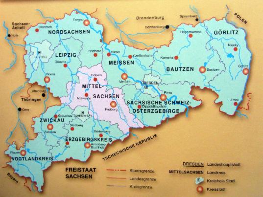
Map of the Free State of Saxony with the Central Saxony district("Mittelsachsen") in the centre
As you can see the Central Saxony District lies in the heart of Saxony and isn't so big. It has an extension of about 2.113 square kilometres. So it's a little smaller than the German federal state Saarland and the country Luxembourg.The Central Saxony District was established by merging the former districts of Döbeln, Freiberg and Mittweida as part of the district reform of August 2008.
Some more facts in brief:
Extension of the district
The most south-eastern point: Community of Rechenberg-Bienenmühle, borders to the Saxon Switzerland region in the east
The most southern point: The Kohlberg Mountain with its 837 metres height, not so far from the village of Neuhausen, in the Ore Mountains
The most western point: The town of Penig, entry town to the Valley of Castles on the river Zwickauer Mulde
The most northern point: The Ostrau community, near the "Lommatzsch Pflege", rich in agriculture, fertile loess soils
The longest north-southeast distance: about 70 km
Surface
The Central Saxony district is divided into four landscape sections from north to south: The Leipzig Lowland, the Hilly area, the foothill of the Ore Mountains and the ridge region of the Ore Mountains.
Main rivers
The river Zwickauer Mulde, the river Zschopau and the river Freiberger Mulde
Population
The Central Saxony district has a population of 41.400 inhabitants.
Economic profil
Variety of mixed branches of industry, craft, service and agriculture, based on many small and medium-seized businesses
Main business branches are: mecanical engineering and motor manufacturing, semiconductor industry, electrical engineering and electronics, timber industry, paper production and print industry, sheet metal and plastics production, biosensory and recycling industry.
Famous regions to visit
We'd like you to recommend to visit the following regions and places: The Valley of Castles alongside the river Zwickauer Mulde, the Kriebstein Recreation Area with the Kriebstein Dam, the Ostrau community- the northest region of the Central Saxon district, Doebeln-the "Town of Boots" near the "Lommatzsch Pflege", the town of Leisnig with the Mildenstein Castle, the Hunting Castle of Augustusburg, the district capital Freiberg with its cathedral and"Golden Gate", the town of Neuhausen in the midst of the Ore Mountains Region("Erzgebirge").
District capital
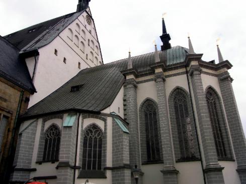
The famous Cathedral of Freiberg
The district capital is the town of Freiberg with about 41,000 inhabitants. It is also called "Silver Town" because silver was found and mined in that region. It lies on the famous "Silver Road" which leads to the Czech Republic. The town of Freiberg is also well-known for its cathedral and the Saxon Mountain Academy, a technical university which deals with matters of geology and mining.
In addition to that this website wants to open an "international window" to Fort William and its sur- rounding in the West Highlands of Scotland. In this connection it will recommend the visitors some beautiful places to stay there. See pages "Fort William" and "B&B Woodside".
Furthermore there will be a special page with detailled information on the book "Ben Nevis-Groß- britannien's höchster Berg. Eine Bildreise mit Reiseinformationen". It was published in German and
can be ordered on that website. See page "Ben Nevis book".
Für deutschsprachige Besucher:
Im 2. Teil willl diese Webseite ( siehe Seiten "Fort William" und "B&B Woodside") vor allem deutsch- sprachige Besucher ansprechen. Der Central Saxony Discoverer öffnet dazu den Besuchern ein "internationales Fenster" nach Fort William und seiner Umgebung im westlichen schottischen Hochland. In diesem Zusammenhang werden Landschaften und Sehenswürdigkeiten vorgestellt, die es sich lohnt, einmal zu besuchen. Das Gebiet Fort William ist ein Urlaubsparadies in freier Natur, wo es sich in jeder Jahreszeit lohnt, Urlaub zu machen . Nicht umsonst trägt sie den Beinamen "Outdoor capital of the UK". Dies soll verbunden werden mit einen kleinen Tipp für eine fantastische Aufent- haltsmöglichkeit.
Auch Teil 3 dieser Webseite ist eine spezielle Seite für deutschsprechende Besucher mit Informationen über das Buch "Ben Nevis- Großbritannien's höchster Berg. Eine Bildreise mit Reiseinformationen". Dieses ist in Deutsch abgefasst und kann bei Amazon.de bestellt werden.
Wenn Sie Anfragen zu Reisen nach Fort William, Schottland und den oben genannten Ben Nevis-Buch haben, dann schicken Sie uns doch eine eMail: info@centralsaxony-sightseeing.de